About
Glismann Road Area Development Plan approved
Cardinia Shire Council approved the Glismann Road Area Development Plan (GRADP) at its meeting on 17 November 2025.
Council allocated funds in its 2024–2025 Budget for the preparation of the Glismann Road Area Development Plan (GRADP). In January 2025, Urban Design & Management (UDM) was appointed to prepare the plan.
This plan is a statutory requirement under Development Plan Overlay Schedule 19 (DPO19) and is supported by the Development Contributions Plan Overlay Schedule 5 (DCPO5), which ensures coordinated infrastructure delivery and equitable cost sharing.
Landowners can now apply for planning permits to subdivide or develop their land, provided proposals align with the GRADP and planning controls.
What is the GRADP?
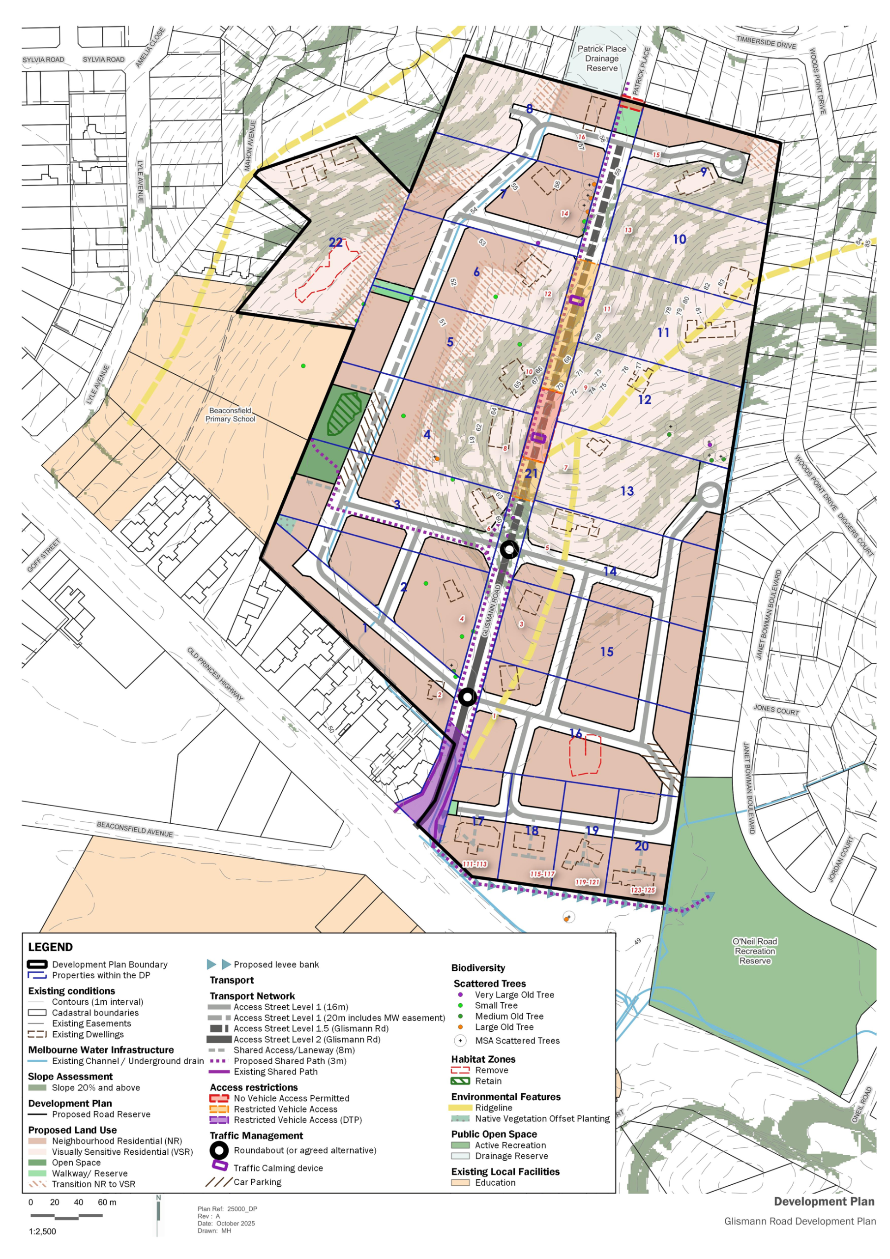
The approved GRADP it’s a comprehensive document combining detailed plans, diagrams, and written guidelines to guide development across 21 land titles, and includes:
- Vision & Objectives: How the area will become a connected, attractive neighbourhood while protecting its natural character.
- Road & Path Network: Plans for linking all properties with safe roads, shared paths, and pedestrian connections.
- Residential Typologies: (1) Neighbourhood Residential – conventional and medium-density lots on flatter land and (2) Visually Sensitive Residential – larger lots on steeper slopes, with strict slope management.
- Residential Design: Lot layouts, housing types, and building guidelines for both flatter and steep land.
- Slope & Landscape Management: Rules for retaining walls, earthworks, and vegetation retention.
- Open Space & Community Links: Location of the new local park and connections to O’Neil Recreation Reserve.
- Infrastructure & Utilities: Drainage, water, sewer, and integrated water management requirements.
- Connection to the Glismann Road Development Contributions Plan (DCP): Identifies infrastructure items funded through the DCP, including roads, roundabouts, shared paths, and open space.
- Property-Specific Guidance: Detailed notes for each land parcel to support permit applications.
Following Council approval of the Glismann Road Area Development Plan (GRADP) in November 2025, Cardinia Shire Council endorsed minor updates to the approved GRADP at its meeting on 18 May 2026. These changes are administrative in nature and do not alter the overall vision, layout or development outcomes of the GRADP. The updates affect text on three pages of the document and do not introduce new policy, change development expectations, or modify the intent, direction or strategic outcomes of the approved GRADP. Tracked changes are provided in Attachment 3 of the Council Meeting Agenda (pages 166–168).
Where can I find the GRADP document?
A stamped copy of the development plan can be found under the ‘Documents’ tab.
Amendment C238 information
Cardinia Planning Scheme Amendment C238 rezoned land in the Glismann Road Area to the Neighbourhood Residential Zone (NRZ2) to allow for residential subdivision using a development plan (DPO 19) and development contributions plan (DCP 05). More information about Amendment C238 can be found on the Cardinia Planning Scheme Amendment C238 page.
The Glismann Road Area Development Plan Overlay (GRADP) (DPO19) requires that the Glismann Road Development Plan must be:
- Approved by Council before any permits for subdivision can be granted.
- Prepared for the entire site and be generally in accordance with Figure 1 of DPO19.

Figure 1: Cardinia Planning Scheme, Schedule 19 to Clause 43.04 - Figure 1: Glismann Road Development Plan
Objectives of the GRADP
- To create a residential precinct that delivers high quality urban design outcomes through a variety of lot sizes which respond to the existing natural topography and landscape features of the development plan area.
- To protect and maintain the visual prominence of vegetated hilltops and hillsides when viewed from within and outside of the development plan area.
- To encourage a subdivision layout which maximises the retention of existing vegetation, minimises the overall disturbance to the terrain and ensures that buildings and structures are sited so that they do not visually dominate the landscape.
- To guide an integrated and coordinated design approach to an area with fragmented land ownerships.
Informal Landowner Engagement
Informal Landowner Engagement
During the Planning Scheme Amendment Panel Hearing, Council committed to continue engaging with landowners and key stakeholders throughout the preparation of the Glismann Road Area Development Plan (GRADP).
Before finalising the Glismann Road Area Development Plan (GRADP), Council undertook informal engagement with landowners and key stakeholders to ensure the plan reflects local priorities and practical considerations.
What was the purpose?
- To share information about the project and its requirements under DPO19.
- To gather feedback on development challenges, opportunities, and community aspirations.
- To improve the quality and deliverability of the Development Plan.
How did engagement occur?
- Letters and information packs sent to all landowners.
- A dedicated project page on Creating Cardinia.
- Individual meetings (in-person and online) held in May 2025.
- Opportunity for written submissions and questions.
What did we hear?
- Strong interest in progressing development but concerns about access and infrastructure delivery.
- Requests for flexible staging and alternative road connections to reduce reliance on non-participating properties.
- Support for retaining vegetation and ensuring high-quality design outcomes.
- Desire for clear guidance on slope management, retaining walls, and housing typologies.
How was feedback used?
- The feedback informed key elements of the GRADP, including:
- Connectivity solutions across 21 land titles.
- Clear slope management guidelines and building design principles.
- Practical staging and infrastructure delivery options.
- Landscape-led design to protect the area’s character.
Where can I find out more about the Landowner Informal Engagement?
A copy of the Engagement Outcomes Report can be found under the ‘Documents’ tab.
FAQs
As shown in Figure 1 (below), 21 properties are affected by the ‘Glismann Road Area Development Plan’:
- 1 to 16 Glismann Road;
- 111 to 123 Old Princes Highway; and,
- 11 Mahon Avenue.

Figure 1: Properties affected by the Glismann Road Area Development Plan
The Development Plan must be generally in accordance with Figure 1 (of the DPO19 Schedule shown below) and include a vision statement, objectives, requirements and guidelines that will guide development in the development plan area.
Figure 2: Cardinia Planning Scheme, Schedule 19 to Clause 43.04 Glismann Road Area Development Plan (GRADP) (DPO19) Figure 1

The Glismann Road Area Development Plan will consist of written text, plans and drawings and respond to the requirements of DPO19, which includes the following topics:
- Site analysis
- Slope Management Guidelines and Design Principles
- Staging
- Housing requirements and subdivision
- Vegetation, Landscape and views
- Public open space
- Road network and movement
- Integrated water management and utilities
'Generally in accordance with' means there's some flexibility in following the approved plan (Figure 1 of DPO19).
Minor modifications are permissible, and each case is evaluated based on its specific circumstances. Any variation would require Council approval and would need to satisfy the objectives of the approved Glismann Road Area Development Plan.
For example:
- a detailed site assessment can provide a more precise information to determine the extent of land that falls within the "substantial area of slope 20% and over" category, or
- a minor realignment to the road layout may be better suited to the land's topography or achieve a more efficient lot layout.
Any changes to DPO19 will require a planning scheme amendment, which involves community consultation and can take up to two years, incurring significant costs. Given the recent approval of the Cardinia Planning Scheme amendment AmC238card, which rezoned land and implemented DPO19 and DCPO5, it is unlikely that another amendment request to change DPO19 would be supported by Council at this time.
The AmC238card amendment process allowed for thorough debate and was assessed by an independent Panel appointed by the Minister. The Panel resolved that in terms of the Glismann Road area the Panel supports:
- the use of the Neighbourhood Residential Zone
- the use of the Development Plan Overlay
- the proposal for Council to prepare the Development Plan.
Council is responsible for evaluating the proposed Development Plan. As part of this evaluation, feedback from the landowners affected by the Development Plan will be considered. All feedback from the informal engagement activity will be reviewed before finalising the Glismann Road Area Development Plan for Council adoption.
No, you are not required to subdivide or develop your land.
Following Council approval of the Glismann Road Area Development Plan, the timing of development is at the discretion of the landowner.
The sale or transfer of the land does not trigger a development contribution payment.
The Development Infrastructure Levy (DIL) is payable upon subdivision of the land.
The Community Infrastructure Levy (CIL) is paid by the landowner of the newly subdivided lot prior to the issuing of a building permit for any new dwelling.
The rates you pay depend on your property's value compared to others in Cardinia Shire. Independent valuers assess your property's value each year.
If property values in the Glismann Road Area go up, your property's value might increase too, which could change your rates. For more information about how rates are calculated go to https://www.cardinia.vic.gov.au/info/20063/your_rates.
Zone
The majority of the Glismann Road Area is in the Neighbourhood Residential Zone – Glismann Road Development Plan Area, Schedule 2 to Clause 32.09 (NRZ2).
One site in Mahon Avenue is in the General Residential Zone, Schedule 1 to Clause 32.08 (GRZ1).

https://planning-schemes.app.planning.vic.gov.au/static/maps/C238card/card/cardinia12zn.pdf
https://planning-schemes.app.planning.vic.gov.au/Cardinia/ordinance/32.09
https://planning-schemes.app.planning.vic.gov.au/Cardinia/ordinance/32.09-s2.
https://planning-schemes.app.planning.vic.gov.au/Cardinia/ordinance/32.08
https://planning-schemes.app.planning.vic.gov.au/Cardinia/ordinance/32.08-s1
Development Plan Overlay
The requirements for the Glismann Road Area Development Plan (GRADP) can be found in Schedule 19 to Clause 43.04 Development Plan Overlay (DPO19).

https://planning-schemes.app.planning.vic.gov.au/s...
https://planning-schemes.app.planning.vic.gov.au/Cardinia/ordinance/43.04-s19.
Development Contributions Plan Overlay
The requirements for the Glismann Road Development Contributions Plan can be found in Schedule 5 to Clause 45.06 (DCPO5).
The Glismann Road Development Contributions Plan is incorporated in the Cardinia Planning Scheme under Clause 72.04.

https://planning-schemes.app.planning.vic.gov.au/static/maps/C238card/card/cardinia12dcpo.pdf
https://planning-schemes.app.planning.vic.gov.au/Cardinia/ordinance/45.06 and https://planning-schemes.app.planning.vic.gov.au/Cardinia/ordinance/45.06-s5.
Environmental Significance Overlay
The requirements for the Environmental Significance Overlay for the Northern Hills can be found in Schedule 1 to Clause 42.01 (ESO1).

https://planning-schemes.app.planning.vic.gov.au/Cardinia/ordinance/42.01
https://planning-schemes.app.planning.vic.gov.au/Cardinia/ordinance/42.01-s1
Documents
Approved Development Plan
Glismann Road Development Contributions Plan
Background documents
-
 Beaconsfield Biodiversity Assessment (Ecology Partners) (October 2010)PDF (24.61 MB)
 -
Glismann Road Contaminated Land Study (Meinhardt) (July 2022)PDF (11.54 MB)
-
Glismann Road Cultural Heritage Management Plan (Tardis Enterprises) (Nov 2010)PDF (7.07 MB)
-
Glismann Road Development Contributions Plan Project Sheets (November 2022)PDF (2.38 MB)
-
Glismann Road Drainage Scheme (Water Technology) (Jul 2014)PDF (2.48 MB)
-
Glismann Road Drainage Scheme Additional Flooding and Water Quality Assessments (Water Technology) (May 2016)PDF (2.55 MB)
-
Glismann Road Landscape Assessment (Hansen Partnership) (June 2014)PDF (22.87 MB)
-
Glismann Road Landscape Management Framework (Hansen Partnership) (August 2014)PDF (17.59 MB)
-
Glismann Road Traffic Impact Assessment (Trafficworks) (May 2022)PDF (5.75 MB)
Privacy Statement
We are collecting your feedback to inform various Council projects. To see our complete Privacy Policy please see cardinia.vic.gov.au/site/scripts/terms.php#
Cardinia Shire Council privacy collection statement
Personal information collected by Council, its external service providers or contractors is in strict adherence with the Privacy and Data Collection Act 2014 and used for municipal purposes as specified in the Local Government Act 2020. The personal information will be held securely and used solely by Council for these purposes and/or directly related purposes. Council may disclose this information to other organisations if required by legislation, and who are bound by substantially similar obligations. The applicant understands that the personal information provided is for the above purpose and that they may apply to Council for access to and/or amendment of the information. Requests for access and/or correction should be made to Council’s Privacy Officer on 1300 787 624 or mail@cardinia.vic.gov.au


