About
Proposed landscaping upgrade
Bonette Reserve is home to the Beaconsfield War Memorial. it is located at the intersection of Wood Street and (old) Princess Highway, Beaconsfield.
The Beaconsfield Structure Plan, which guides the growth and development of Beaconsfield sets out strategies to improve the area around the War memorial on the corner of Woods Street and (old) Princes Highway. The Historic Memorial and its immediate context are considered by the structure plan to represent an important Civic node for the town of Beaconsfield.
The project team (Council in conjunction with Urban Initiatives as the appointed consultant) is committed to designing a landscape upgrade to Bonette Reserve in Beaconsfield, in consultation with the community.
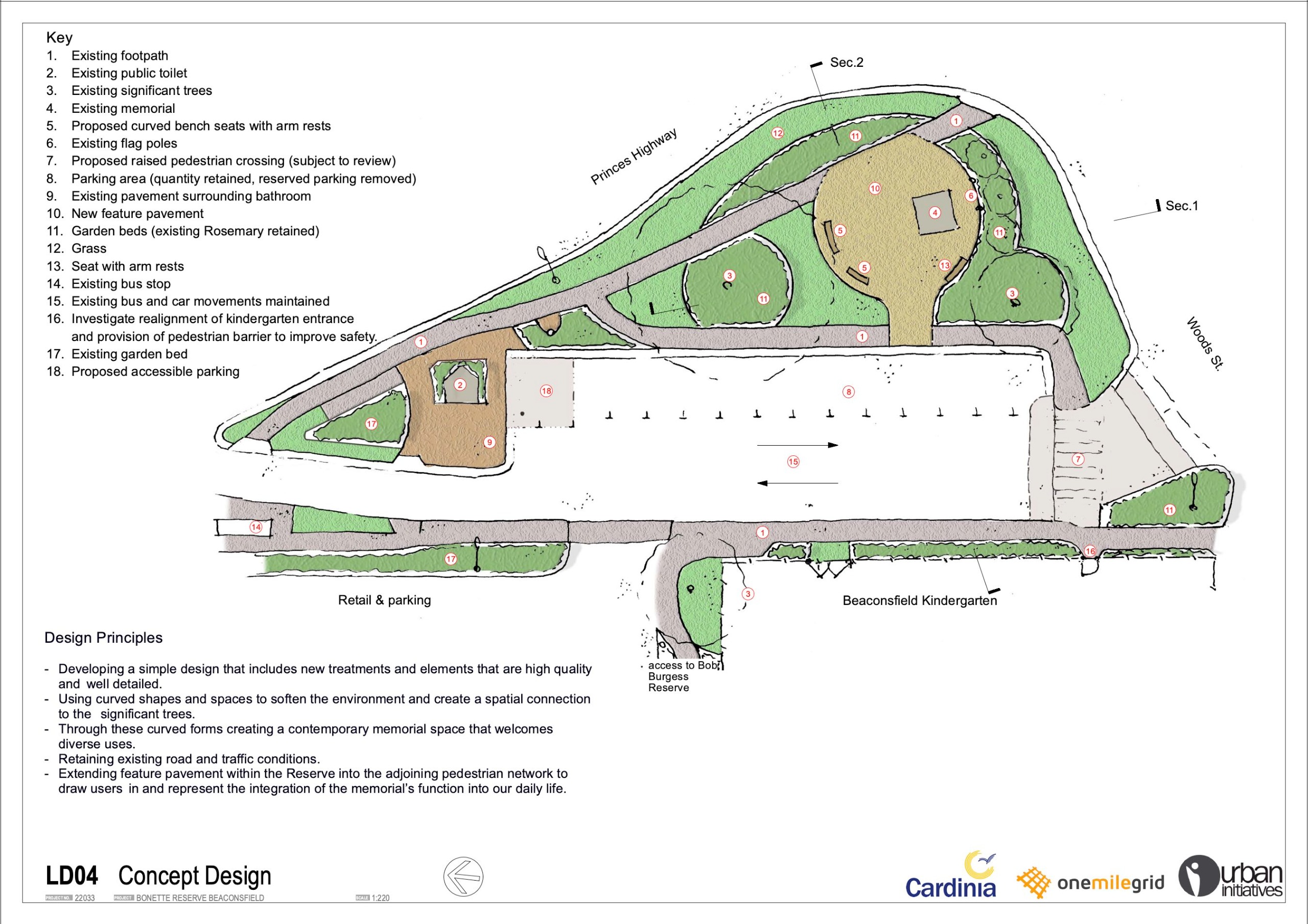
We are seeking your views about the proposed concept design shown below. Please complete the short questionnaire underneath concept design diagram.
Project update
Upgrades are now complete on the Bonette Reserve Memorial in Beaconsfield.
Works included:
- Pavement works around the memorial.
- Footpath upgrades
- Accessible pedestrian crossing
- Replacement of flagpoles
- Accessible parking
- Seating
- Garden beds and landscaping
- Drainage improvement works
We would like to thank the community for their support, patience and understanding through this project’s consultation period and construction. 95% of the works are now completed.
Consultation
Feedback was requested to inform the Bonette Reserve, War memorial landscaping upgrade. Our survey is now closed.
Thank you to the members of the community who gave feedback regarding the Bonette Reserve War Memorial Landscape Upgrade Concept Plan, through our online survey and multiple information pop-up sessions within the reserve.
There was an overwhelmingly positive response and great level of support for the concept design, with most comments centred around event days (e.g. traffic mitigation, power supply and flagpoles) or improved usage of the reserve (e.g. parking, better pedestrian access, planting and additional seats).
In addition to the community consultation, the concept design was provided to the Department of Transport and Planning (DTP). The feedback received from DTP has seen some minor adjustments to the design to improve pedestrian and road users’ safety, through risk mitigation and removal of minor hazards on site.
Based on your feedback, Council is refining the design and consulting with relevant stakeholders. Once the design is finalised, construction is scheduled to take place in late 2023, subject to successful tendering and favourable weather conditions.
If you have any further questions, please head to the FAQ’s on the right hand side of this page.
Past consultation sessions
We hosted two information 'pop-ups' in the park on:
- Sunday 13/11/22 between 11.00am and 1.00pm
- Wednesday 16/11/22 between 3.30pm and 5.30pm
PRIVACY STATEMENT
Personal information collected by Council is used for municipal purposes as specified in the Local Government Act 2020. The personal information will be held securely and used solely by Council for these purposes and/or directly related purposes. Council may disclose this information to other organisations if required or permitted by legislation. The applicant understands that the personal information provided is for the above purpose and that they may apply to Council for access to and/or amendment of the information. Requests for access and/or correction should be made to Council’s Privacy Officer on 1300 787 624 or mail@cardinia.vic.gov.au
To see our complete Privacy Policy please see Privacy, copyright and disclaimer
FAQs
The aim is to provide an equivalent number of car parking spaces at the site to what is currently available (i.e. 14 spaces)
One of the parking spaces will be redesigned to become an accessible (disabled) car parking bay for people with disabilities. This will involve some minor roadworks including realignment of parking spaces and kerb and channel work.
Council is proposing to remove the ‘Reserved Parking’ sign and markings on five car parking bays along Woods Street. The purpose is to bring parking signage in line with current Australia standards and to achieve unambiguous and enforceable parking restrictions and allocations in the area.
Bonette Reserve is a small triangular shaped open space located at the north-western corner of Woods Street and Old Princes Highway, Beaconsfield. Home to the Beaconsfield War Memorial, the reserve is located opposite the Beaconsfield Kindergarten and in close proximity to Bob Burgess Reserve.
Please refer to the Document Library above for a map showing the project area.
The reserve is named after a well-known resident called George Leonard Francis Bonette. The name of the reserve was gazetted in August 2020.
In 2013, Cardinia Shire Council adopted the Beaconsfield Structure Plan to guide the growth and development of Beaconsfield. The Structure Plan sets out strategies to improve the area around the War Memorial on the corner of Woods Street and Old Princes Highway. The memorial and its immediate context are considered by the structure plan to represent an important Civic node for the town of Beaconsfield.
Some of the key features of the proposal include:
- New feature pavement to support the reserve’s function as a ceremonial space. The pavement will be connected into the existing footpaths to improve access
- New raised pedestrian crossing (subject to review and approval from relevant road authorities) to support and enhance pedestrian connectivity whilst maintaining access for buses and vehicles
- New seating
- New landscaping
- New lighting to give greater prominence to the Beaconsfield War Memorial and improve the reserve as a place of reflection and a significant landmark to the local community
- Maintain public parking provision and redesign one of the spaces to become an accessible (disabled) car parking bay for people with disabilities. Remove the ‘Reserved Parking’ sign and markings to bring parking signage in line with current Australia standards
- Investigate realignment of kindergarten entrance and provision of pedestrian barrier to improve safety
- Retain and protect existing significant trees
- Retain and protect War Memorial, flag poles, public toilet and bus stops
Bus services and infrastructure including bus stops will not be affected. We will not be proposing any changes to traffic flow and movement within this plan.
This plan is proposing to construct a new raised pedestrian crossing to improve pedestrian connectivity whilst maintaining access for buses and vehicles. This is subject to review/approval from the relevant road authorities.
The proposed plan covers several improvements for accessing the reserve. This includes providing accessible parking bay and creation of a well-connected paved area with seating to improve access and to support events.
The toilet has been recently upgraded and no further works will take place in this area as part of this plan.


